Jomolhari Trekking Tour – Bhutan
Tour Highlights
The Jomolhari Trek, also known as the Chomolhari Trek, is one of the most popular and iconic trekking routes in Bhutan. Bhutan is a small Himalayan kingdom located in South Asia, known for its stunning natural landscapes, rich culture, and unique approach to measuring the country’s success through Gross National Happiness (GNH) rather than GDP. The Jomolhari Trek offers trekkers the opportunity to experience the beauty of Bhutan’s pristine wilderness and immerse themselves in its unique culture.
Here are some key details about the Jomolhari Trek:
Location: The Jomolhari Trek is located in the western part of Bhutan, near the border with Tibet (China). It takes you through the Paro and Thimphu valleys, allowing trekkers to witness the breathtaking scenery of the Himalayan mountains.
Duration: The trek typically takes around 7-9 days to complete, depending on the specific itinerary and pace of the trekking group.
Highlights:
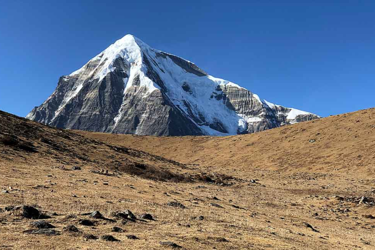
Mount Jomolhari: The trek gets its name from Mount Jomolhari (Chomolhari), which is the second-highest peak in Bhutan (7,314 meters or 23,996 feet). Trekkers can see this majestic mountain up close during the trek.
Natural Beauty: The route takes you through lush forests, alpine meadows, and pristine lakes. You’ll also encounter rivers, waterfalls, and a variety of flora and fauna.
Cultural Experience: Along the way, you’ll have the opportunity to visit remote villages and interact with the local people, providing insight into Bhutanese culture and traditions.
Hot Springs: The trek passes by several natural hot springs, providing a relaxing and rejuvenating experience after days of hiking.
Altitude: The trek involves crossing high mountain passes, with some sections reaching altitudes of over 4,000 meters (13,000 feet). Trekkers need to acclimatize properly to avoid altitude sickness.
Permits and Regulations: Like all treks in Bhutan, the Jomolhari Trek requires a licensed guide, and a government-issued trekking permit is necessary. The number of trekkers is also regulated to preserve the environment and minimize the impact on the region.
Best Time to Trek: The ideal time for the Jomolhari Trek is during the spring (March to May) and autumn (September to November) when the weather is relatively stable, and the views are spectacular.
Difficulty: The trek is considered moderately challenging. While it doesn’t involve technical climbing, trekkers should be prepared for long days of hiking, varying weather conditions, and challenging terrain.
Logistics: Trekkers typically fly into Paro International Airport in Bhutan and then make their way to the starting point of the trek in Paro or Shana
Day 1 :Arrival-Thimphu, the capital city of Bhutan. Approx. Alt: 2300 m. Dist. 1 Hours, 55 Km
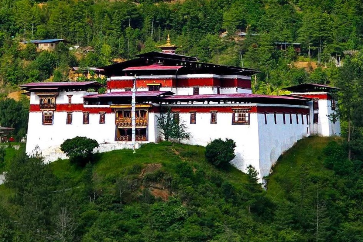
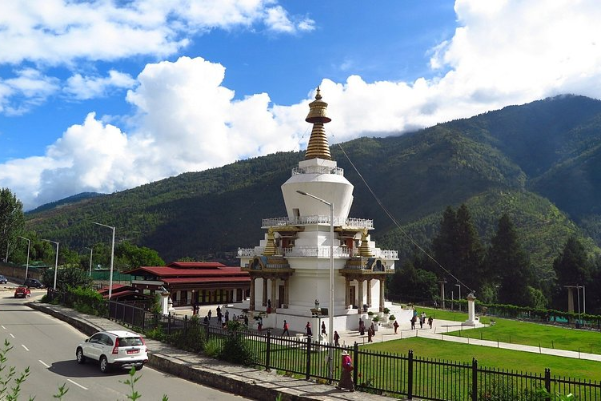
Upon arrival you will be transfer to hotel through fascinating valley of Paro to Thimphu. Later visit Memorial Stupa, Majestic Tashichhodzong, which houses office for the king and the ministers. Evening leisure in town. Overnight in Thimphu in Hotel
Day 2 :To Punakha, the old capital of Bhutan. Approx.Alt:1200 m. Dist. 2 hours
Before moving to Punakha we will visit some sites in Thimphu including Takin Zoo, Buddha Point, Painting school and Samtokha Dzong. Later drive to Punakha across Dochula pass (3,100m). Catch glimpse of eastern horizon. En route make short excursion about an hour to the temple of divine madman, also well known as the temple of fertility. Later visit suspension bridge. Overnight in Punakha in Hotel
Day 3 : Punakha
Morning short excursion to Khamsum Yuelley Namgyel Chorten, Enjoy catering lunch at bank of river. After lunch visit Punakha Dzong situated at the junction of Pho Chu and Mo Chu Rivers. Overnight in Punakha in Hotel
Day 4 :Punakha-Thimphu
After breakfast drive back re-routing Punakha Thimphu high way via Dochula pass. Hike to lungchutse Monastery for approx. 3 hours (to and form) and catch glimpse of eastern horizon. Upon arrival Thimphu visit garment shop for shopping for trek gears.
Day 5 : Thimphu-Paro (Trek Starts)Approx.12km, 4-5 hours, 360m Ascent and 80m Descent
Early morning drive from your hotel to Shana village, about 2 hrs to the road end. First day is a moderate trek to start with, the trek leads into Jigme Dorji National Park through the valley of the
Paro river, which gradually narrows as the trail leads higher, winding up and down through the thick forest of oak, pine and juniper. Overnight in camp
Day 6 : Thongdozam-Thangthangka Approx. 9Km. 4-6 hours trek, 500m Ascent / 50m Descent
Continue up through the valley, following Paro river, which gradually narrows as the trail leads higher, winding up and down through a thick, lush forest of oak, pine, cider and juniper, as we get closer to our camp for the night. Overnight in tents at around altitude of 3600m
Day 7 : Thangthangka- Jangothang Approx. 15km/6hr trek – 500 ascent/ 50m descent
Continue following Paro river as the valley begins to widen, opening to a spectacular area surrounded by high ridges and snow-capped peaks. A few yak- herding villages are based in this area. Due to altitude gain, the pace is typically slower. Camp at Jangothang (4,080m) below a ruined fortress with Mt. Jhomolhari, which now seems nearby. Overnight in tents.
Day 8 : Jangothang Halt
Jangothang is one of the most spectacular camping places in the entire Himalayas with the perfect view of the Mt.Jumolhari and Jichu Drake right in the front. There are yak herders villages and trout filled lakes to visit. The sacred mountain remains unclimbed and off limit to mountaineers even from the Tibetan side. Depending on your interest you can walk towards the glaciers of Jumolhari, or up to the view point where you can get better view of the majestic mountains or visit the village and interact with the local community.
Day 9 : Jangothang-Yaktsa Approx,16 km,6-7 hours,810m ascent and 1090m descent.
The trail starts with a steep climb after crossing the small wooden bridge leading to the lake of Tshophu (4380m). After crossing the second glacier lake the trail descends into a hidden valley and climb steeply to Bonte La pass at 4890m. From the pass it is all down hill with an opportunity to see Himalayan blue sheep grazing on the hillside. Gradually we make our way to Soi Yaksa village and camp for overnight at 3800m. Overnight in camp
Day 10 :Yaktsa-Thumbushong Approx.11km, 5-6 hours, 720m ascent and 340m descent.
The trail starts with gentle uphill climb to the top of the eastern ridge of the Soi Yaksa valley. From here enjoy the views of the mountians in the north. The tips of the Jumolhari and Jichu Drake reappear on the distant horizon as you approach. Cross Takhung La pass (4520m) and after a short descent leads into a wide and grassy Thongbushong valley. You will come across nomadic yak herders camped in their traditional woolen tents and stone huts. Camp for overnight at 4180m Thangbushong Valley. Overnight in Camp
Day 11 :T h u m b u s h o n g – Gunitsawa-Paro Approx.11km, 4-5 hours, 200m ascent and 1650m descent.
After a short steep climb from the camp, we leave the remote mountain valley by following a ridge to Thombu La (4380m). Then steep descent trail most of the afternoon through the pine forest. Arriving at the Gunitsawa army post, pick up by the vehicle and drive about 1 hr to our hotel, we bid farewell to the trekking staff and drive to Paro. Overnight at Paro in hotel
Day 12 : Paro-Taktsang Hike
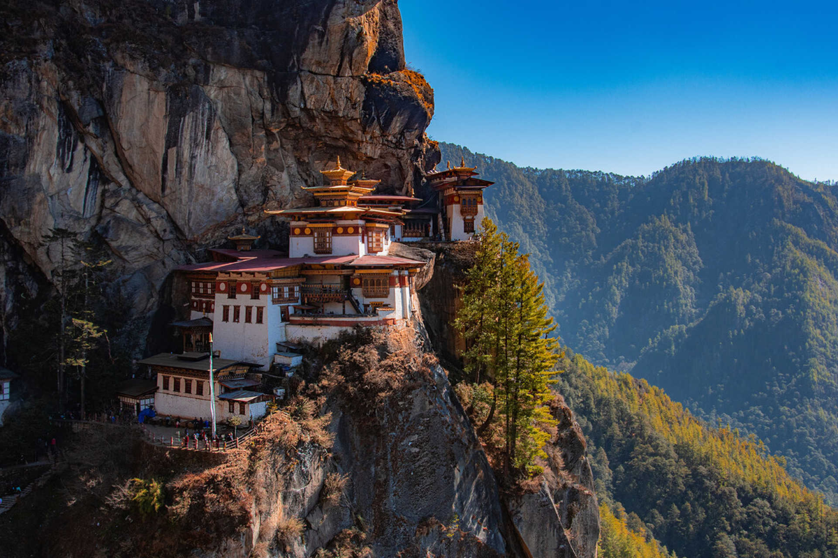
Day excursion to Taktsang Monastery, Tiger nest monastery a quintessential Bhutan travel experience. After lunch visit to Ta Dzong (national Museum) and Rinpung Dzong (the fortress of the heap of Jewels built in the 17th century). Later visit Kyichu Lhakhang, Dungtse Lhakhang. Evening leisure walk in and around Paro mini town by your own. Overnight in Paro in Hotel
Day 13 : Paro-Departure
After breakfast guide will drive you to the airport and help you with the baggage and bid farewell for the homeward journey
Tour Price
Price On Requestper person | All inclusive
Book This Tour
Need Help?
Our travel specialists are available 7 days a week to answer your questions and help you plan your perfect adventure.
Office Hours: Mon-Sun, 9 AM - 7 PM (EST)
Email: booking@bhutanluxurytour.com